A Bike Trip To Sach Pass: The Toughest Pass In India
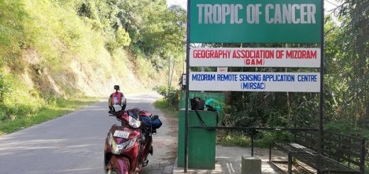
A few months back I was writing an article on Mountain Passes in India situated in Himalayan Mountain Range. At the time of writing that article I read about all the passes of India, the valleys they connect, their importance to India and primarily the Indian Army. I had already planned Leh-Laddakh Trip with my college friends and during that trip, I had planned to visit many of the passes that I mentioned in my article. One mountain pass that amazed me was “Sach Pass” which is situated in Himachal Pradesh at an elevation of 4230 meters. Sach Pass is termed as one of the dangerous passes in India and it is very critical for the Indian army as well as for people living in that region.
Sach Pass connects the Chamba Valley of Himachal Pradesh to the Pangi Valley and during its construction terrorists tried to stop the construction. Sach Pass is accessible for only five months in a year (June to October) and heavy snowfall in the region prevents people from traversing this pass. I have already made my mind cross this pass with my bike and all I was waiting for was an opportunity. Since my Leh-Ladakh trip was scheduled to start from Jammu, we all had to transport our bike to Jammu. I went a step ahead and planned to get my bike to Jammu via riding from Delhi. So, I decided to start my journey from Delhi, cross Sach Pass and then park my bike in Jammu. This served two purposes, one, my bike will be in Jammu for my trip and two I will be able to visit the Sach Pass I always wanted. In this article, I will be sharing my bike trip to Sach Pass, the route I followed to reach Pass, the condition of roads while traveling to Sach Pass, mobile connectivity and various other do’s and don’ts while planning a trip to Sach Pass. I hope my article will be helpful to other riders planning to visit Sach Pass. If you have any questions or doubt do let me know via comments and I will be glad to help you out.
Qucik Navigate:
Why Trip to Sach Pass is better than any other Mountain Pass in India
As I mentioned earlier there are many mountains passes in India and every year hundreds of people visit these passes. Most of the passes of Himalayas lie in the state of Jammu & Kashmir and a trip to Leh-Ladakh covers many of them. Sach Pass is different from other passes as it is less traveled by people and while the passes in Leh have good road, accessibility to basic amenities, and better places to stay, the Sach Pass lacks all these things. Once you will be close to Sach Pass you will feel the difference why it is different from the rest of the Mountain Passes in India. Sach Pass is not a tourist hub like Khardung La Pass or Chang La Pass, there is no formal marking or signboard (even after reaching the Sach Pass) and tourist hardly visits this pass. If you cross Khardung La or Chang La pass then you get to view the beautiful Nubra Valley or the Pangong Tso Lake but after crossing Sach Pass all you will get is 120Km or more road in its worst form. The pass is hardly accessed by tourist and mostly the people of Chamba and Pangi Valley use it for transportation of goods. The advantages of less vehicle and tourist movement are that you will see Pass with greenery and would be able to find snow even in July (although it is a lesser height than other passes in India). For a traveler visiting a place, trying to click a few photographs, Sach Pass is not an ideal place but for a real rider, it is one big challenge that they are ready to take.
My Bike Trip to Sach Pass And The Route I Followed
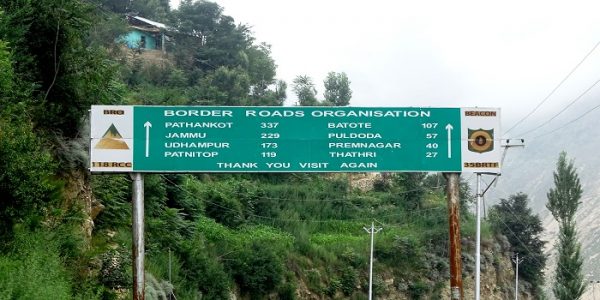
Working in an IT company has one big disadvantage i.e. it’s hard to get leaves and it becomes nearly impossible when you have already applied for 16 days’ leave for Leh. I had time constraints so I started my journey on Friday after completing my shift. I had already done my packing and once I reached my room, tied my saddlebags on the bike and started the journey. My ride started from Noida at 5:30 PM and my first biggest challenge was to cross the famous Delhi Traffic and reach Karnal By-Pass. I was lucky enough as I didn’t find much traffic and only 10 minutes were wasted while crossing the Kashmiri Gate ISBT. I reached Karnal by-pass around 6:15 PM and once I crossed it all I had to do was to clock my bike to its best speed. The route I followed to cover the Sach Pass was Delhi -> Pathankot-> Banikhet -> Tissa -> Bairagadh -> Sach Pass -> Killar -> Gulabgadh -> Kishtawar -> Patnitop -> Jammu -> Delhi.
Day One: Delhi to Pathankot
So, I crossed Karnal By-Pass around 6:15 PM and after that riding was like a piece of cake. Delhi to Pathankot (in fact Jammu) is one of the best roads in India and once I crossed Sonepat the remaining Delhi traffic was gone. From Sonepat, I crossed Panipat, Kurukshetra (I have already completed Bike Trip to Kurukshetra), Ambala, Chandigarh and took my first halt at Ludhiana. After a break of 30 minutes, I was again in my riding seat and my target was to reach Pathankot and end the first day of my journey. After Ludhiana, I crossed Jalandhar and finally reached Pathankot at 2:30 AM. Upon reaching Pathankot I booked a room for the night stay and planned to start my next day journey around 9 AM.
Day Two: Pathankot to Bairagadh
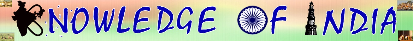
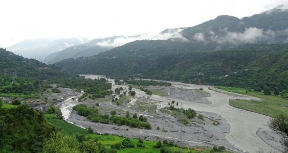
I had planned to cross Sach Pass on the second day of my journey and take the halt in Killar but nothing happens as you plan. Being the monsoon season (the day was 30th July) it started raining heavily in the morning and I had to wait for nearly 3 hours for the or rain to stop. Around 11:30 AM the intensity of rain decreased and I resumed my journey from Pathankot. Since it was still raining I had to limit my speed around 20-30 Km/hr which caused delay to my entire plan and I reached Banikhet around 2 PM. There is a T-Point from where one road leads to Dalhousie while others towards Chamba. I took a half-hour break at one of the Dhabba and talked with locals. They gave me a better idea for my journey and the route I should follow. From Banikhet, there is a straight route to Chamba and from Chamba, you need to proceed for Tissa. From Tissa, Bairagadh is 30Km. They also recommended to visit the Bhalei Mata Temple and seeks blessing. Another not to miss a thing on this route is the Chamera Dam built by NHPC. Chamera Dam is built on the Ravi River and the view of Dam, as well as its reservoir, is spectacular. Since it was raining from all day, the weather was pleasant but at the same time cloudy.
After visiting Chamera Dam and Bhalei Mata Temple I reached Tissa around 5:00 PM and by that time I had already made my mind to stay in Bairagadh (It was also recommended by local people). After 7:00 PM it was like you are driving amidst of clouds and roads were hardly visible. From Tissa to Bairagadh the roads are steep (Bairagadh is at 2800 meter) and precaution should be taken as at many stretch roads is under construction and slippery due to mud and construction leftover. I reached Bairagadh around 8 PM and planned to go to the PWD guest house in Bairagadh. I saw two Royal Enfield bikes standing at hotel Chamunda and since it was already dark, I decided to stay at Hotel Chamunda rather than going to PWD guest house. I met with both riders and they were coming back from Sach Pass and they have followed Delhi-Jammu-Killar Route. One Royal Enfield met with a severe accident and its leg guard was broken, backside holder was broken and entire engine oil drained. After getting an update of Sach Pass from them I went to my room and started preparing myself for the third day of my journey.
Day Three: Bairagadh to Sach Pass and Kishtawar
Bairagarh To Sach Pass
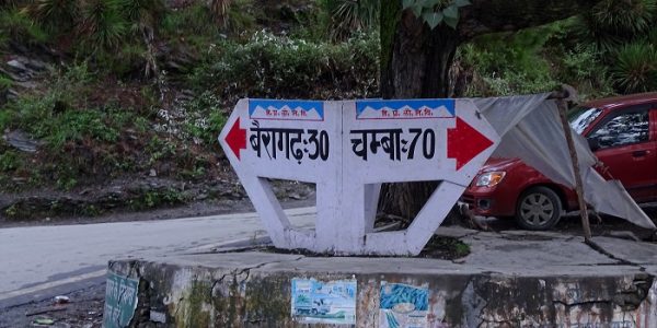
The third day was the toughest and most challenging day of my journey as I had to cover both the Sach Pass and the bad terrain-following Sach Pass. I started early in the morning so that I can cover the maximum distance. Since Bairagadh is already at 2800 Meters height morning was very cold and foggy and the road was hardly visible. As I covered 1Km towards Sach Pass the condition of the road started deteriorating and pitched road was replaced by bumpy rock-filled narrow roads with a water crossing. Since I started early in the morning, the water crossing has little water which helped to cross them (it is always advisable to cross the water crossing or the nallas early in the morning). After covering nearly 12 Km there is a final check post operated by Himachal Pradesh Police in Satrundi, where they will make a short video film of you along with your vehicle. They will ask for valid ID proof and ask you to stand near your vehicle while they make a video. This is used for documentation purposes so that in case of any miss happening there is information that person successfully crossed this check post. The Satrundi check post also has a small shop where you can find necessary food items and it also provides night accommodation in 200 Rupees per bed. Make sure you have necessary things like water bottles, biscuits or other stuff because once you have crossed this shop you won’t find a single shop next 80KM. From the police check post, Sach Pass is only 20Km and the road gets narrower and the temperature drops further.
Also Read: Bike Ride To Chanshal Pass Covered in Snow
Sach Pass To Killar
Anyways I reached the Sach Pass by 10:30 AM and when I reached the top was all cloudy. At Sach Pass, there is a small temple dedicated to Lord Shiva and Goddess Kali (called Polhani Devi Temple) and the wall of the temple has marking (Sach Pass 4500 Meters). I went to the temple and thanked God for making my journey successful and prayed that the further journey remains smooth. Since I also brought my drone with me, I waited for one hour for the weather to get clear and I can get a perfect shot for both my camera and my drone. After waiting for one hour the sky becomes a little bit clear and I started recording Sach Pass with my drone. Once the drone battery drained, I started preparing for my last leg of the journey. From Sach Pass, Killar is nearly 40Km but in this 40Km you will driving in one of the worst roads. Also, once you have crossed Sach Pass, you will be descending from 4300 meters and you have to control your bike on slopes and nallas.
Killar To Kishtwar
Since I had to go to Kishtwar (Not Killar), there is a cut once you are approaching Killar town (5 kilometers after crossing the bridge on the Chenab River). From that cut, the road will lead you to Kishtwar and it is called Tandi-Kishtwar Road. I covered that 40Km distance in 2 hours and 30 Minutes. Beware of the Junction where one road leads to Killar and other to Kishtwar. There is no marking and the road is like any usual village road which one can ignore. The next big town on this route will be Gulabgadh in Paddar Valley of Kishtwar which is nearly 60 Km from Killar. Google Maps shows that the distance from Killar to Gulabgadh can be covered in 1 hour and 30 minutes but it is the biggest joke.
I took nearly 3 hours to cover the distance as the path can’t be termed as a road. It was a sandy path with big rock boulders laying everywhere. It took nearly 3 hours to cover that 55Km of distance. During my entire journey from Bairagadh to Gulabgadh, I was riding on 1st or 2nd gear and it is the most challenging road I faced in my entire journey. Once Gulabgadh is approaching the condition of the road gets better but still, the road will restrict your speed below 30Km/hr. I reached Gulabgadh around 6:00 PM and decided to halt my journey of the day. Since I had to catch my train the next day in the afternoon and from Gulabgadh, Jammu was still 290Km, I decided to ride further up to Kishtwar town which will ease up my next day journey. From Gulabgadh, Kishtwar is further 70Km and I reached Kishtwar around 9:00 PM in the night. From Bairagadh to Kishtwar the distance is nearly 176 Km and as per the google map it will take 5 hours (4-hour 30 min) to cover this distance, but in reality, it took nearly 14 hours to cover this distance. After riding for 14 hours I was completely exhausted so I booked a room at Kishtwar Bus stand and ended my third-day journey.
Day Four: Kishtwar to Jammu
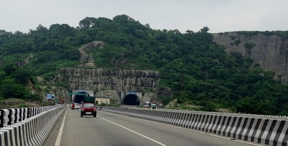
I started my next day ride around 8:00 AM as I have to cover 230Km more and I planned to reach Jammu by 2 PM. From Kishtwar onwards the road is very good and excluding a few stretches, you will find the road in excellent condition. From Kishtwar I crossed Doda around 10:00 AM and reached Patnitop around 11:30 AM. From Patnitop, I entered the Chenani Nashri Tunnel which was inaugurated by PM Narendra Modi this year. The tunnel is an engineering masterpiece and reduced the distance by 35Km or 2 Hours. After crossing the tunnel, the next big town is Udhampur but the road from Chenani-Nashri Tunnel to Udhampur is very tough to ride. The road is in good form but the heavy movement of trucks and tourist vehicle make it difficult to ride a motorcycle. Also, the road is filled will mud and potholes which restricts the speed. Anyways once you cross Udhampur you will get the best road of your journey. The Jammu-Udhampur highway is a six-lane highway and it will take only one hour to cover the remaining 70Km. I reached Jammu City around 1:45 PM and parked my bike at my friend’s home (next week I had to come again to start my Leh-Laddakh Trip from Jammu). After parking my bike, I went to Jammu Railway Station and the train was on time.
I have tried to explain my Sach Pass journey in the best possible way and I thank readers for reading my experience. A Ride to Sach Pass is always considered tough as compared to any other mountain pass in India not only because of rough terrain but also because of lack of facility as compared to other mountain passes. There is very little information on the internet about how to plan a trip to Sach Pass or the difficulties while riding to Sach Pass. I hope my article will help future riders on their journey. In case anyone has any doubts or want further clarification, you can drop a mail or write your query in the comment section.

Never been to any of them. The plan for Triund has been hanging for so long now. Once I was suggested to visit Sach Pass for trekking while on my trip to Dalhousie & never visited that too.
By the way, it was a very nice article, thanks for sharing!