Toughest Road In India: A Ride From Pangong Tso To Tso Moriri Lake in Ladakh
A bike ride is always full of adventures and those traveling on Bike can easily relate to it. I mean a trip on a car is also memorable and I have done many in the past but the freedom a motorcycle gives cannot be compared with a car. A car comes with comfort but with a bike, one enjoys the road to its fullest extent. A ride with bike allows you to venture to the remotest area and places where a car driver would think twice to step in. Sometimes these off-roading gives you memories of the lifetime and I experienced a similar while traveling from Pangong-Tso to Tso-Moriri Lake in Ladakh. I have ridden to some of the remotest and toughest roads in India but the ride on route mentioned was far difficult than it can be described by words. I faced similar difficulties as I faced when I was covering the Sach Pass with only one difference that this time I was in a group rather than solo. I encountered similar experiences while riding from Haflong to Silchar and I will be covering that in my Experience of North-East India. In this article, I will be sharing my Bike Ride Experience from Pangong-Tso to Tso-Moriri, the route taken by us, road conditions in the entire route and the availability of Petrol, food and other commodities. I will be explaining why this route should be explored by all the riders despite the challenges it offers and would mention a few do’s and don’ts that should be taken into consideration while attempting this route. Hope this will be helpful for future travelers and in case any suggestion is required I would be glad to help.
Qucik Navigate:
Why One Should Ride from Pangong-Tso to Tso-Moriri?
Before explaining why one should ride on the above route we all should agree to one thumb rule which is “Leh-Ladakh is all about Biking“. Many travels by car, but the wilderness of Leh-Ladakh is best explored and experienced on a Motorcycle. Few may not agree with it because of the discomfort a bike brings but then we all should remember “the greatest of the view comes after the hardest climb“. Coming back to the question, one can visit Pangong-Tso from Leh, return to Leh and next day visit Tso-Moriri as the road from Leh to both the lakes is quite good. Following the above will cost you three days to cover both the lakes while the same can be achieved in two days with the route we covered. Some will say why to visit both as both are a lake and Pangong-Tso is the largest one and experience is going to be similar in Tso-Moriri. Somewhere it is true as the Pangong-Tso is the largest lake and only 40% of its whole area lies in India. 60% of Pangong-Tso Lake lies in China and that’s why one should attempt this route. Few reasons for this are:
- A 40Km ride Parallel to bluish water of Mighty Pangong-Tso Lake.
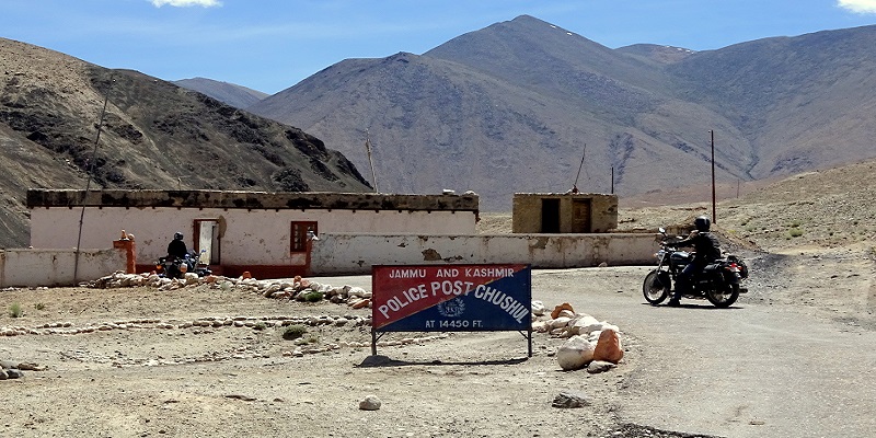
- Visiting Chushul, last village on Border of India-China.
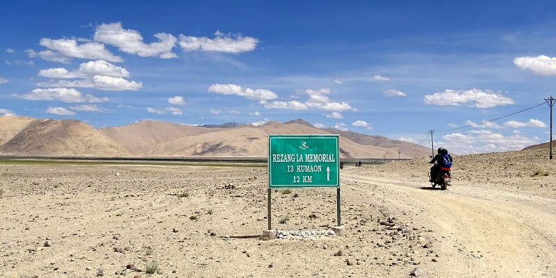
- A chance to visit Rezang La War Memorial.
- Loma Bend and an encounter with Overflowing Indus River.
- More than 120+ Km of Off-Roading from the entire 200Km of the ride.
The Route I followed vs The Route Should be Taken
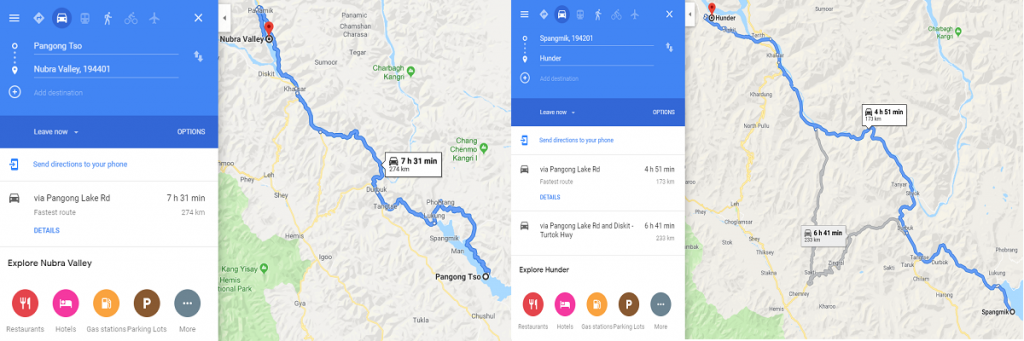
If you will rely on google maps, then there is going to be a lot of confusion and panic because google map will show you a route which can be confusing. The reason why I am saying this is because most people will search based on landmarks which will force google to show any location lying in that area or updated by someone. For example, if you search Nubra Valley to Pangong Tso the map will show a total distance of 274Km which is enough for anyone to get confused. The best search will be from Hunder (in Nubra Valley) to Spangmik (Village on Pangong) and then the distance will be 180Km (Less than 100Km). So, for traveling between Pangong Tso to Tso Moriri use Spangmik Village as a starting point and Karzok Village as the end.
The route we followed was:
Pangong Tso -> Man -> Marek -> Chushul -> Mood -> Nyoma -> Mahe -> Karzok Village (Tso Moriri)
There is an alternate route from Chushul to Mahe via Mirpal Tso in which you have cross Kaksang La (17,800 Feet). One thing to notice before embarking on any of the routes is to ensure that you have ILP (Inner Line Permit) in place with places mentioned where you will be riding else there are chances defense personal will not allow you to proceed further. I will recommend the route I followed unless you are traveling for a second or third time and looking for something different and out of the box. Moreover, the route I mentioned has small towns in en-route making the journey less painful than it is. One more thing to keep in mind is to leave early in the morning from Pangong lake (By 9 AM) to reach Tso Moriri by time. We wasted some time in clicking photos and reached Tso-Moriri very late in shivering condition.
My experience on Ride from Pangong-Tso to Tso-Moriri
Ride From Pangong Tso To Chushul Village
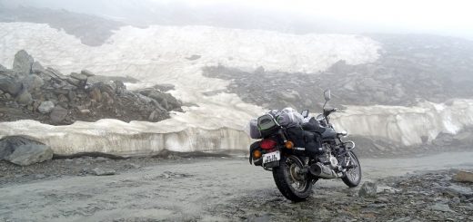
When we started our journey, we were already late by 2 hours and it required us to ride faster to coverup the lost time, but the road was in such a bad condition that maintaining a speed of 30Km/hr seemed difficult. I was unaware of this fact that only 40% of Pangong Tso lake lies in India and 60% in China and when I saw the vastness of the lake, I could not comprehend how big the lake is. We rode almost 35Km parallel to the lake. A 35Km ride along one of the highest lakes in the world is something a biker always wished for. The dark blue color of water hitting the shore and speeding winds made the journey more memorable and forced us to stop multiple times to take photos (we were already late). After crossing one bend en-route we were amazed by the width of the lake as it looked it has no end. After a two-hour ride along the lake which reached the town of Chushul which is one of the places on the International Border of India. The town looked deserted with few stores open. We stopped for a Maggie break and discussed with locals for the further route. One strange answer we heard was: “Don’t take right anywhere if there is a cut use left or else you will end up in China“. The statement was enough for everyone to get terrified about the future leg of the journey. As suggested, we proceeded to Mood Village which was around a 70Km ride from Chushul. As mentioned, there were no roads and we were just riding on a patch of land surrounded by sand. Our only source of navigation was the tyre marks from earlier vehicles. There was a point after riding non-stop for some 2 hours that we were curious if we really are in India or somehow missed a diversion as there was no sign of human or animal. No home, no landmark or an army bunker or check-post. After riding for some 30 minutes we finally got a signboard stating “Rezang La War Memorial 20Km” and we got our breath back.
Ride From Chushul To Mahe
Next was time for us to visit the Rezang La War Memorial built for the martyrs of the 1962 India-China war. For us and most of the Indian 1962, India-China War is a sad history as we lost to China but after reading the heroics of our brave soldiers everyone had a different mindset. We discussed the effects of war and Heroics of Major Shaitan Singh (Posthumous Param Vir Chakra) and I ended up writing the famous Nathu-La Standoff between India and China in 1967. The route is an endurance test for riders as well as his/her bike from Chushul to Mood as there is hardly any road and proximity to the border makes everyone skeptical if they are still in India or crossed the border. Anyways a further one-hour ride and we reached to the ITBP check-post and in Mood and everyone was happy that they are still in India.
Between Mood and Mahe there will be 3-4 ITBP check post and ensure that you have done your entry on every check post. Don’t act smart and skip because if they found out that you have skipped the one you will be forced to come back and do your entry else you won’t be allowed to cross next check post. Form Mood village one route will lead you to Hanle where Indian Astronomical Observatory is situated. Hanle is also famous for the 17th Hanle Monastery of the “Red Hat” Tibetan Drukpa Kagyu branch of Tibetan Buddhism. Form Mood village we started for Mahe which was the next town in the route, and it was on this leg we faced the biggest challenge of our journey. The road on this leg runs parallel to the Indus river and the river was overflowing or say flooding. This 30Km was a hell of a ride as the road was submerged in the water forcing us to ride on the sand. Riding on sand comes with a daunting task of maintaining balance which further slowed us down. Anyways things were going fine until we saw a curve submerged in water up to waist length. One the other side there was a hill stopping us to take an alternate route. Apart from our group few more groups were standing there figuring out what can be done next. There was no scope of returning as we had already struggled to reach this point and going back was not in the picture.
Anyways keeping fear aside, a Pick-Up Van ventured to go first and got stuck halfway which created a panic among all. It looked like everything was standstill as no one knew what to do. Suddenly we saw a Jammu & Kashmir State Dept bus carrying passengers coming from the opposite direction and it successfully crossed it. We all keenly noticed the path and then thought of riding on the same to cross it. The biggest fear was what if we skid and fall in the river as there was no way to distinguish where the river bank ends and from where waterlogging starts. Anyways remembering our god, I started my bike and closely rode on the same path which bus took keeping accelerator up avoiding water in silencer. I successfully crossed the 90% of the patch but fell in last but to my luck, the water was not deep, and I was able to pick up my bike and cross the rest by walking. Once I crossed the water crossing successfully, everyone regained their courage and started following the same path. Finally, we all crossed the water crossing and by the time we reached Mahe, it was 5:30 in the evening and started getting dark.
Ride From Mahe To Karzok Village And Tso Moriri
From Mahe to Karzok Village there was a further 60Km of the ride and we were expecting at a max of 2 hours to reach Tso Moriri but riding in dark was something to be taken care of. Moreover, I was completely wet after falling in Indus water and I was shivering from cold. Anyways we continued our journey and as Tso Moriri was getting closer the road started getting worse. Before entering Karzok Village we did the last entry on ITBP check post and the next 15Km we were riding on rock boulders. There was a sound of water hitting the shores and we all knew that it is Tso Moriri Lake and we are riding parallel to it but due to the darkness we were not able to see it. Finally, we reached our camp by 9 PM in the night and we all were shivering in cold. One reason was the cold wind blowing at an elevation of 4500 meters and second, we all were fully or partially wet because of the water crossing we encountered in our route. We don’t know how many cups of Tea and Soups we consumed before starting our dinner but 3-4 cups per person won’t be a wrong figure. After dinner, no one had the strength to even talk or discuss anything and we all knew that it is the best time to hug our beds. We enjoyed the beauty of Tso-Moriri, clicked photos in different angles and shot time-lapse but all was done the next day. I hope this experience would help the people trying to attempt this route. If any further info is required do message/comment me and I would help you out.
Do’s and Don’ts on Ride from Pangong Tso to Tso Moriri Lake
- Start early in the morning, don’t waste time clicking photos more than required. If attempting for a time-lapse wake up early and start moving by 9 AM.
- Keep ILP documents in place. Ensure you have enough photocopies. Defense personal might not ask on every check post but extra copies are not going to harm anyone.
- Keep enough cash and petrol. Although you can get petrol in the black rate in Mahe Town and Chushul.
- Puncture kit and an air pump are mandatory. Why I am saying this because between Leh and Pangong you might get some help bu between Pangong Tso and Tso Moriri, only Army can help.
- The road is in very bad shape between Pangong Tso to Mood and then last 20Km before Tso Moriri. Be prepared for that.
- A windcheater would be handy apart from jackets and sweaters and carry good gloves.
- Try booking camps in advance in Tso Moriri as it is not as famous as Pangong Tso is and there are fewer chances of getting accommodation after reaching there especially if traveling in a group. For a person or two, there might be some changes but for groups, it is recommended.