
Amazing Facts about International Border of India
The International border of India is 3rd largest in the world after China (22,147 Km) and Russia (20,017 Km). Apart from the International border of 15,200 Km, the border of India includes an additional coastline of 7515 Km. India shares its international border with seven countries (If POK is taken into account) which is also one of the highest in the world. The partition of India in 1947 and then the partition of Pakistan in 1971 resulted in an increased number of neighboring countries as well as an increase in the length of the border of India. The border of India is one of the sensitive borders of the world with extreme climatic conditions. There are many interesting places, facts, and history associated with the international border of India. Through this article, we are presenting you with a list of interesting and historical facts about the border of India.
List of Amazing Facts About Border of India
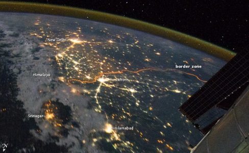
1) The border between Indian and Pakistan is visible from space. It is due to 0.15 million orange lights installed on 50 thousand poles by the Indian Government to counter smuggling and arms trafficking. In 2011 NASA took a photo of the India-Pakistan border that clearly showed the borderline between the two countries.
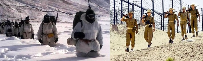
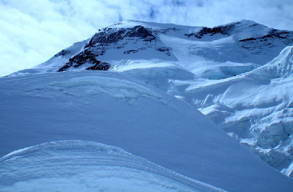
2) According to PBS (Public Broadcasting Service), the border between India and Pakistan is one of the most dangerous borders in the world. The India-Pakistan border in the north has Siachen Glacier (world’s second-longest glacier) where the temperature goes as low as -60°C followed by Karakoram Range (contains the second highest peak in the world K2). Going down, the border passes through the Thar Desert where the temperature goes as high as 50°C and annual rainfall as low as 100mm. These borders are guarded by the Border Security Force of India.
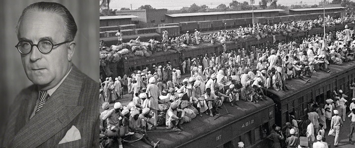
3: The task of creating the border between India and Pakistan was given to Sir Cyril Radcliffe (Redcliffe Line was named after him) but the fact was Cyril Radcliffe never visited India before and it was his first trip to India. The members assisting him had no previous experience of carrying out such task nor the Indian climate suited Redcliffe and he was eager to depart India as soon as possible. He knew that no matter what he does people would suffer after the partition and to escape justification he “destroyed all his papers before he left India”. The implementation was also done quickly and only two hours were given to representatives of both countries to study the final result.
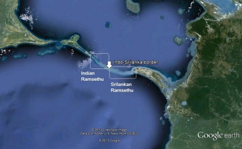
4) India and Sri Lanka form the shortest land border in the world. The length of the border between these two countries is 100 meters! Both the countries are joined by a narrow stretch of Adam’s Bridge (Rama Setu in Hindi). According to reports, the bridge was passable on foot up to the 15th century and the history books state that Adam’s Bridge was completely above sea level until it was hit by the cyclone in 1480 AD which increased the depth of the sea.[wp_ad_camp_3]
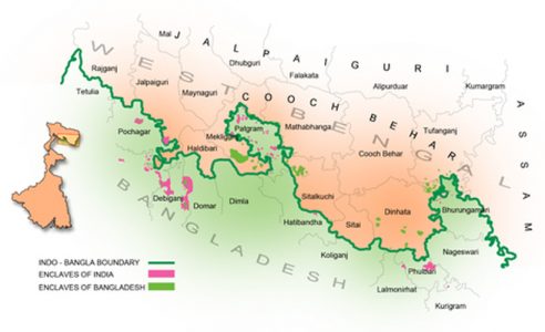
5) The border between Indian and Bangladesh is the most separate segment of land borders between any two countries in the world with nearly 199 enclaves in this border. In Bangladesh, there were 102 enclaves of Indian Territory, which in turn contained 21 Bangladeshi counter-enclaves. In the Indian mainland, there were 71 Bangladeshi enclaves, containing 3 Indian counter-enclaves.
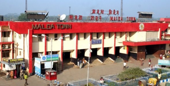
6) Malda District of West Bengal faced one of the most disputed partitions. The Malda District had a slight Muslim majority, but the district was divided and most part of it, including Malda town, went to India. The district was under the administration of East Pakistan for 3–4 days after 15th August 1947. When the award was made public then the Pakistani flag was replaced by the Indian flag. Today also Malda district celebrates its Independence Day on 17th August two days after Independence Day of India. [wp_ad_camp_4]
7) The Border between India and Bangladesh (4,096 Km) is the fifth-longest land border in the world. Border greater than this is Canada-United States (8,893 Km), Kazakhstan-Russia (6,846 km), Argentina-Chile (5,300 km), and Mongolia-People’s Republic of China (4,677 km).
8) Dahala Khagrabari was an enclave on India-Bangladesh border and it was the world’s only third-order enclave. Dahala Khagrabari was completely encircled by the Bangladeshi village of Upanchowki Bhajni which in turn was surrounded by Indian village of Balapara Khagrabari and it was then encircled by Debiganj, Rangpur Division of Bangladesh. You may sometimes need a Bangladeshi visa to reach here. After the land agreement of 2015, India ceded the enclave to Bangladesh.
[wp_ad_camp_2]
9) Tin Mukh Peak (also known as Tin Mata) in Tripura is a peak that marks the meeting point of the borders of Bangladesh, Myanmar, and India. In the same way, Jongsong Peak, lying in India in Himalayan Range is another three-way boundary. At this point, the border of Nepal, China, and India meet with each other. At Siachen Glacier (currently controlled by India) the border of India, Pakistan, and China meet.
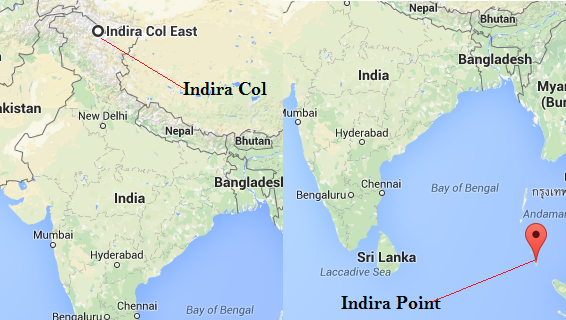
10) Indira Col (disputed territory administered by India) and Indira Point are the extreme point of India in North and South. Indira Col lies in the northernmost point of Siachen Glacier and Indira Point in the southern end of Andaman and Nicobar Islands. After the Tsunami of 2004, the Indira point was submerged into the sea but now the water from the sea is retreating and the point is again visible.
11) Town of Kuttanad on the western coast of India in the Alappuzha, Kottayam Districts of Kerala has the lowest altitude in India (7.2 ft below the sea level). It is one of the few places in the world where farming is carried out at an altitude below the sea level.
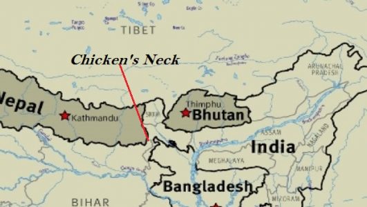
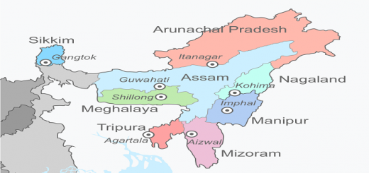
12) The northeastern part of India is connected to the Indian mainland by a narrow stretch of land called Chicken’s Neck (also known as Siliguri Corridor). The lowest width of Siliguri Corridor is only 14 miles and it is the only way for connectivity to the north-eastern state and its 40 million trade. It is a very important location for Indian Defense forces and it is heavily patrolled. In past China has tried to choke the vulnerable Siliguri Corridor and cut off the Northeast from the Indian mainland. India’s friendly relation with Bhutan also keeps the Chinese Army away from reaching this corridor.
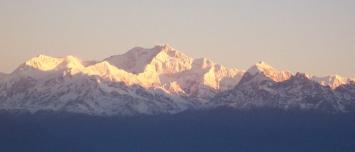
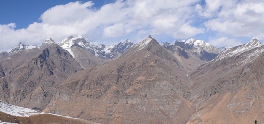
13) India’s Border with Nepal, China, and Bhutan is the world’s second-highest border (first being China-Nepal). The border that passes through this region contains some of the highest peaks in the world like Kangchenjunga(8586 m), Jongsong Peak (7462 m), Kabru N (7412 m) e.t.c.
We have tried to provide you the best information from different sources. It will allow you to know better about Indian Borders and crucial and important. We would be adding more interesting facts. If you really liked our article then please refer (sharing on Facebook & Twitter) so that it can reach to more people.

thank you for this