List of Mountain Ranges & Mountains in India
Mountains are one of the classifications of earth topography, and they are present in almost every continent of the earth. We have the Rocky Mountains in North America and the Alps in Europe, the Ural Mountains in Russia to the Himalayas in Asia. India is one of the diverse nations on the planet and has several mountain ranges running the length and breadth of the country. There are many mountain ranges in India, and they can be seen throughout the Indian subcontinent. Broadly classifying there are seven Mountain ranges in India and these ranges have some of the highest mountain peaks in India as well as in the world. In this article, we will cover mountains in India, major mountain ranges in India, classification of mountains in India, the importance of mountains in India, the highest mountain peak in India and famous places situated in the mountains in India.
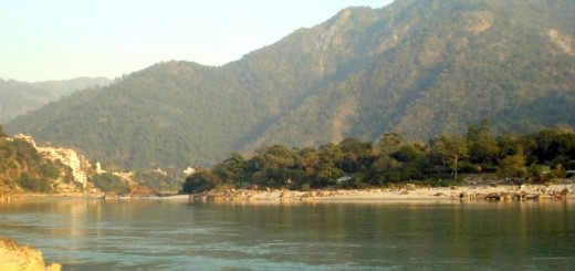
As said above, India is one of the most diverse countries in the world, and the credit of this diversity goes to distinct flora & fauna and various types of physical topography. Northern India has The Great Himalayan Range, and it separates the Indian mainland from the rest of Asia. The Himalayas is one of the longest and oldest mountains in India, and hosts almost every largest peak in the world. In central India, we have Satpura and Vindhya Range that separates northern and southern India. Going west, we have Aravalli Mountain Range, which is the oldest mountain in India. Going further south, we have Western and Eastern Ghats mountain ranges that separate coastal plains on either side. Eastern and the Western Ghats are made of multiple mountain ranges and are one of the main centers of tourist attraction. Hill stations like Ooty, Kodaikanal, Jog Falls, and Tamhini Ghat are situated in these ranges.
Read Also: List of Major Rivers of India and Their Tributaries
The Western Ghats are the world’s “Greatest biodiversity hotspots” they have thousands of different species of plants and animals and is visited by thousands of tourists. These mountain ranges play a significant role in India. They are not just for tourist purposes but also play a very crucial role in India’s culture and environment. These high mountain ranges affect India’s climate, and they are the source of many important Indian rivers like Ganges, Narmada, and Mahanadi, etc. They have a significant impact on Indian mythology, and many important events are associated with them. To study mountains in India is an exciting topic, and a large number of researchers from all over the world come here just for study purposes.
Read Also: Amazing and Interesting facts about Ganges River Every India should Know
Qucik Navigate:
List of Mountain Ranges in India
- The Great Himalayan Mountain in North
- The Karakoram and Pir Panjal Range
- Eastern Mountain range or The Purvanchal Range
- The Satpura and Vindhya Range
- The Aravali Range
- The Western Ghats
- The Eastern Ghats
The Great Himalayan Mountain
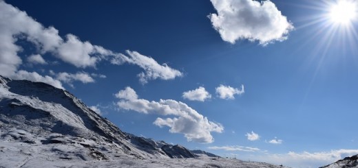
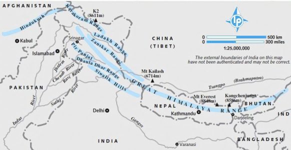
Himalayan Mountain is a new fold mountain formed by the collision of two tectonic plates. This mountain range has almost every highest peak in the world, and on average, they have more than 100 peaks with a height of more than 7200m. The height of Himalayas is so great that excluding K2 or Godwin Austen remaining 9 of 10 highest peaks lie in this range. The word Himalaya is derived from the Sanskrit word meaning “abode of the snow.” Himalayan Mountain has a total length of 2400 km and width varies from 400 km to 150 km. Nanga Parbat and Namcha Barwa are the western and eastern points of Himalayas. “Mount Everest” the highest peak of the world (8848m) lies in the Himalayan range in Nepal. The Himalayas is also the source of many great rivers the Ganges, Brahmaputra and Indus all have their origin in the Himalayas. The Indo-Gangetic plain is one of the most densely populated areas of the world that lies in the south of this mountain range. Tibetan plateau surrounds the Himalayas from the north. The Himalayas also play a significant role in regulating the climate in northern India as it prevents cold air from entering the Indian mainland in the winter season.
The Karakoram and Pir Panjal Range
Karakoram Range and Pir Panjal range lies to the North-west and south of Himalayas Range. A significant part of Karakoram Range comes under the disputed territory of India and Pakistan, and both the country claims it. Karakoram Range with the length of 500km is a house of many highest peaks of earth and K2 the second-highest summit in the world at 8,611 m lies here. An extension of Karakorum Range runs as Hindu-Kush in Afghanistan. The Karakoram has most glaciers excluding Polar Regions and The Siachen Glacier, and The Biafo Glacier, are the world’s 2nd and 3rd largest glaciers located in this range. Pir Panjal Range is located in the southern direction of Himalayas starting from Himachal Pradesh in India and running north-west towards Jammu & Kashmir and disputed area of Jammu & Kashmir. This range is also known as Lower Himalayas, rivers like Ravi, Chenab, and Jhelum flow through this range. The city of Gulmarg, which is a famous hill station lies here.
Eastern Mountain Range or The Purvanchal Range
The Purvanchal Range is an extension of Himalayas in the eastern part of India. The process of formation of this range is quite similar to that of Himalayas though Purvanchal Range is not as high as of Himalayas. This range comprises of three parts The Patkai-Bum Hill, The Garo-Khasi-Jaintia Hills and Lushai Hill (Mizo Hills). Mawsynram in Meghalaya is the wettest place on earth because of these hills, and it lies in Khasi Hill. This range covers all the eastern states of India commonly referred to as the Seven Sisters or North-East India.
Also Read: A Solo Ride To North-East India For Sixty Days
The Satpura and Vindhya Range
The Satpura and Vindhya range lie in central India, and both these range runs parallel to each other. Out of these two Satpura ranges is bigger in length and is the source of rivers like Narmada and Tapti. Both these ranges are predominantly situated in Madhya Pradesh and Maharashtra with some extension to Gujrat, Chhattisgarh and Uttar Pradesh. The Kalumar Peak (752m) and Duphgarh Peak (1350m) are the highest points in Vindhya and Satpura range. These ranges are famous for a large no of tourist spots like Panchmarhi Hill Station, Kanha National Park, Amarkantak and Omkareshwar temple.
The Aravali Range
The Aravali Range is the oldest mountain range in India, and it is also one of the oldest mountain ranges in the world. In the local language, it means “Line of Peaks.” The Aravali Range spans a total length of 800 km covering the Indian states of Delhi, Haryana, Rajasthan, and Gujrat. The Aravali Range plays a significant role in the Indian climate as it blocks wind carrying rain to reach the Thar Desert. The width of the range varies from 10km to 100km. Guru Shikhar is the highest point of Aravali Range with a total elevation of 1722m. This range is famous for many tourist attractions. Mount Abu, a famous hill station in Rajasthan, is situated in this range. The city of Udaipur also lies on its southern slope of Aravali Range. Rivers that flow through this range are Banas, Luni, and Sabarmati.
The Western Ghats
The Western Ghats is a 1600m long mountain range that runs from Gujrat to Kanyakumari in central and south India. The range, also known as “Sahyadri Mountains,” comprises of the mountain range of Nilgiris, Anaimalai, and Cardomom. Tapti River marks its beginning in Gujrat and then it runs parallel to Arabian Sea crossing states of Maharashtra, Goa, Karnataka, and Tamil Nadu. Anaimalai Hills with an elevation of 2695m in Kerala is the highest peak of this range. Western Ghats is one of the UNESCO World Heritage Site in the world and has excellent bio-diversity. It is home to some 139 mammal species, 508 bird species, 179 amphibian species, and 250 reptile species. Famous tourist attractions include Jog falls, Ooty, Bandipur National Park. Important rivers in this range are the Godavari, Krishna, and Kaveri.
The Eastern Ghats
The Eastern Ghats is a mountain range running in the eastern part of the Indian Peninsula parallel to the Bay of Bengal. This range is not continuous and is lower in elevation when compared to the Western Ghats and runs through Indian states of West Bengal, Orissa, Andhra Pradesh, and Tamil Nadu. Arma Konda with an altitude of 1680m is the highest peak of this region. The Eastern Ghats have a significant role in Indian agriculture as four major rivers of India, i.e., Godavari, Mahanadi, Krishna, and Kaveri fall into the Bay of Bengal through the Eastern Ghats. Before falling, they create a vast fertile region that is suitable for crops like rice. These ghats are older than the Western Ghats, and they have some famous pilgrim sites like Tirumala Venkateshwara Temple in Andhra Pradesh. Vishakhapatnam and Bhubaneswar are important cities located in the Eastern Ghats.
Read Also: Geography of India